Geovonic is a collection of tools to enhance and extend your ArcGIS organisation. Geovonic will continue to expand as we add new tools to use with your ArcGIS applications.
FAQ
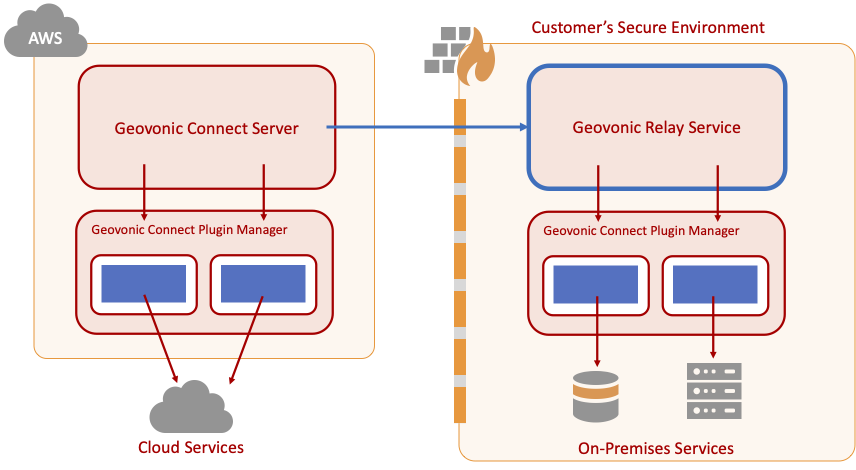
The Geovonic Relay Service provides a tunnel through your firewall to allow Geovonic to interact with your internal business systems and ArcGIS Enterprise portal.
The Geovonic Relay Service runs inside your network and opens a secure socket connection to the Geovonic server, allowing two-way communication. This is a common pattern for communicating with secured resources used by applications such as the PowerBI Data Gateway.
Refer to this article for installation instructions.
Geovonic Relay Service Overview
Boustead Geospatial Technologies (BGT) specialises in using inventive spatial thinking and best-of-breed software development to create new solutions that digitally reinvigorate industries, organisations and/or workflows.
Founded in 2018, the company has a team of dedicated staff operating across Australia, Singapore and Malaysia.
Geovonic Connect has a collection of standard plugins available for all subscribers (e.g. SQL database query, Open-Meteo weather services) and a collection of premium plugins for accessing specific business systems.
Premium plugins are available for purchase to add to your base subscription. If you need access to a premium plugin please contact our support team.
When purchasing or requesting a trial through ArcGIS Marketplace, you must assign a license to yourself, or the person completing the registration process, through your ArcGIS portal.
Geovonic Connect will appear as an add-on license in your organisation. You must assign the license before following the link you receive in the registration email.
Geovonic connects to your ArcGIS Enterprise via the Geovonic Relay Service. If your ArcGIS is configured to use Integrated Windows Authentication (IWA), you must add the NTLM credentials in to the relay service configuration file.
The NTLM user must have an org_admin role in your ArcGIS portal during setup. It should be switched to lower privilege account after setup is complete.
The NTLM user needs to be able to lookup feature layers on your ArcGIS portal.
Windows Service (Default)
When installing the Geovonic Relay Service as a Windows service, you will download the config.ini file from the Geovonic admin console. The config.ini file includes three lines for NTLM_DOMAIN, NTLM_USERNAME, NTML_PASSWORD. These must be filled in with the appropriate values.
Restart your Windows service after modifying the config.ini file.
The Geovonic Relay Service is an optional component that allows Geovonic Connect to access systems running behind your firewall. Install the relay service inside your secure environment to act as a proxy for requests between your business systems and the Geovonic Connect server.
The Geovonic Relay Service opens up a secure web socket to the Geovonic Connect server, allowing queries to be passed to systems running within your firewall.
ArcGIS Online includes many security options that can restrict access to new applications like Geovonic. One example is the restriction only letting users sign in to applications that have been approved by an organisation administrator.
It will seem strange to see a “Host unreachable” error when connecting to ArcGIS Online since it’s hosted in the public cloud, but security settings on your ArcGIS Online account may be restricting access.
Geovonic Connect needs to be able to connect to your ArcGIS Online organisation from the browser. ArcGIS Online has an option to restrict the websites that can make calls to your ArcGIS Online account through Cross-Origin Resource Sharing (CORS) restrictions.
If your ArcGIS Online has restricted CORS domains, Geovonic Connect may show the error message “Host unreachable”.
To check if your ArcGIS Online account is restricting CORS access, go to Organisation -> Settings -> Security and find the “Allow origins” section. CORS restrictions are in place if you have configured at least one application domain. If so, you will also need to add connect.geovonic.com to the list of allowed origins.
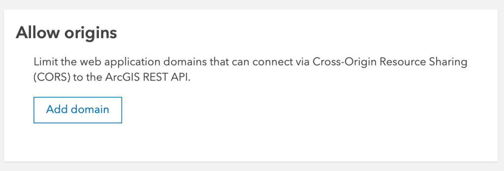
ArcGIS Online Allow Origins
Error messages: host-unreachable, network-error
Geovonic Connect makes calls to your ArcGIS Enterprise to authenticate the user and to authorise the user’s privileges.
If the Geovonic Connect admin console cannot successfully call your ArcGIS Enterprise, you may see the message: “Sorry. There was a problem communicating with the portal.”
Sone common causes for this might be:
- The SSL/TLS certificate on your portal has expired or is unsigned.
- The clock time on your PC is wrong.
- Your ArcGIS portal may be behind a company firewall and the Relay Service is not running.
- Your ArcGIS Portal is using Integrated Windows Authentication (IWA). Make sure you have the NTLM credentials supplied to the Relay Service client.
Error messages: unauthorized-access-arcgis-portal
No. Geovonic Migrate connects to your ArcGIS portal (Online or Enterprise) to discover all the apps you have in your organisation. As Web AppBuilder developer edition runs separately from your ArcGIS portal, Geovonic Migrate is unable to access those apps.
Geovonic Connect makes call to your ArcGIS Portal to authenticate the user and to authorise the user’s privileges.
If the Geovonic Connect admin console cannot successfully identify your ArcGIS Portal, you may see the message: “Sorry. There was a problem signing in. Please try again.”
The cause of this is because you have not completed setting up your ArcGIS Portal with Geovonic Connect. Please look for the email with “Welcome to Geovonic Connect” subject
and click the “Get Started” button in the email. Then, follow through the steps provided.
Error messages: invalid-invitation-code